
[fusion_builder_container hundred_percent=”no” equal_height_columns=”no” menu_anchor=”” hide_on_mobile=”small-visibility,medium-visibility,large-visibility” class=”” id=”” background_color=”” background_image=”” background_position=”center center” background_repeat=”no-repeat” fade=”no” background_parallax=”none” parallax_speed=”0.3″ video_mp4=”” video_webm=”” video_ogv=”” video_url=”” video_aspect_ratio=”16:9″ video_loop=”yes” video_mute=”yes” overlay_color=”” video_preview_image=”” border_size=”” border_color=”” border_style=”solid” padding_top=”” padding_bottom=”” padding_left=”” padding_right=””][fusion_builder_row][fusion_builder_column type=”1_1″ layout=”1_1″ background_position=”left top” background_color=”” border_size=”” border_color=”” border_style=”solid” border_position=”all” spacing=”yes” background_image=”” background_repeat=”no-repeat” padding_top=”” padding_right=”” padding_bottom=”” padding_left=”” margin_top=”0px” margin_bottom=”0px” class=”” id=”” animation_type=”” animation_speed=”0.3″ animation_direction=”left” hide_on_mobile=”small-visibility,medium-visibility,large-visibility” center_content=”no” last=”no” min_height=”” hover_type=”none” link=””][fusion_text columns=”” column_min_width=”” column_spacing=”” rule_style=”default” rule_size=”” rule_color=”” class=”” id=””]
Monuments and Sites
Nearly every village or district in the country is endowed with significant monuments and cultural sites. Those monuments and sites whose significance transcends their local boundaries go through a process specified in the NCAC Act to be declared national monument. Further, those sites with outstanding universal significance are nominated for inscription in the UNESCO World Heritage List.
UNESCO World Heritage Sites
At present The Gambia has two inscriptions in the UNESCO World Heritage List. These are: 1. Kunta Kinteh Island (formerly James Island) and Related Sites, which was inscribed in the World Heritage List in 2003. The site is a serial inscription of several sites that form a historical continuum which illustrate outstanding universal value.
Kunta kinteh Island and Related Sites was inscribed under criteria iii and vi of the criteria for inscription stipulated in the World Heritage and consists of the following sites:
- The ruins of the French and Portuguese settlements at Albreda and Juffureh which are located 1 km west of San Domingo (CFAO Building, Maurel Freres Building and Portuguese Church);
- The Mandingo village of Juffureh, which was popularized by Alex Haley’s ‘Roots’, and the riverside settlement of Albreda;
[/fusion_text][fusion_content_boxes layout=”icon-with-title” columns=”1″ title_size=”” heading_size=”2″ title_color=”#000000″ body_color=”” backgroundcolor=”” icon=”” iconflip=”” iconrotate=”” iconspin=”no” iconcolor=”” icon_circle=”” icon_circle_radius=”” circlecolor=”” circlebordersize=”” circlebordercolor=”” outercirclebordersize=”” outercirclebordercolor=”” icon_size=”” icon_hover_type=”” hover_accent_color=”” image=”” image_width=”” image_height=”” link_type=”” button_span=”” link_area=”” link_target=”” icon_align=”left” animation_type=”” animation_delay=”” animation_offset=”” animation_direction=”left” animation_speed=”0.3″ margin_top=”” margin_bottom=”0px” hide_on_mobile=”small-visibility,medium-visibility,large-visibility” class=”” id=””][fusion_content_box title=”Fort James” backgroundcolor=”” icon=”” iconflip=”” iconrotate=”” iconspin=”” iconcolor=”” circlecolor=”” circlebordersize=”” circlebordercolor=”” outercirclebordersize=”” outercirclebordercolor=”” image=”” image_width=”” image_height=”” link=”” linktext=”” link_target=”” animation_type=”” animation_direction=”left” animation_speed=”0.3″ animation_offset=””]
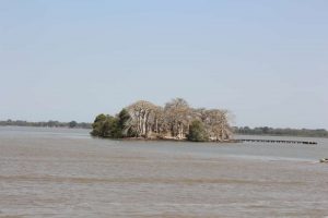
Fort James is situated on James Island about 30km up-river from the mouth of the River Gambia. He history of James Island is unusual in that it reflects political events in Europe, events which had a very direct bearing on the people of The Gambia but which were by and large, beyond the control of the Gambian ethnic groups. The trade forts of West African were set up to primarily defend the interests of the European traders and James Fort (as it is more typically known now) was no exception. Throughout its history this was its main function, but through the periods of peace the fort had a much basic role. It was like a Fortified Company Office (the base of operations for the various trade groups) and it monitored all river traffic and allowed for the collection of levies on river transport. The Europeans that manned the fort were either commercial, military, or professional in background.
[/fusion_content_box][fusion_content_box title=”” backgroundcolor=”” icon=”” iconflip=”” iconrotate=”” iconspin=”” iconcolor=”” circlecolor=”” circlebordersize=”” circlebordercolor=”” outercirclebordersize=”” outercirclebordercolor=”” image=”” image_width=”” image_height=”” link=”” linktext=”” link_target=”” animation_type=”” animation_direction=”left” animation_speed=”0.3″ animation_offset=””]
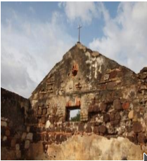
The ruins of the French and Portuguese settlements at Albreda and Juffureh which are located 1 km west of San Domingo (CFAO Building, Maurel Freres Building and Portuguese Church);
[/fusion_content_box][fusion_content_box title=”San Domingo, Juffureh” backgroundcolor=”” icon=”” iconflip=”” iconrotate=”” iconspin=”no” iconcolor=”” circlecolor=”” circlebordersize=”” circlebordercolor=”” outercirclebordersize=”” outercirclebordercolor=”” image=”” image_width=”” image_height=”” link=”” linktext=”Read More” link_target=”” animation_type=”” animation_direction=”left” animation_speed=”0.3″ animation_offset=””]
Located near the shoreline of the river, San Domingo was the foreign quarter of an old Portuguese trade post and the main sub-station for James Island. It was established by the Portuguese in the late 15th century by Luso-African traders who had settled there to act as host-brokers and middlemen for the Europeans.
[/fusion_content_box][fusion_content_box title=”Fort Bullen ” backgroundcolor=”” icon=”” iconflip=”” iconrotate=”” iconspin=”” iconcolor=”” circlecolor=”” circlebordersize=”” circlebordercolor=”” outercirclebordersize=”” outercirclebordercolor=”” image=”” image_width=”” image_height=”” link=”” linktext=”” link_target=”” animation_type=”” animation_direction=”left” animation_speed=”0.3″ animation_offset=””]
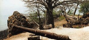
Fort Bullen was the largest fort built by the Europeans in The Gambia and it remains in good condition today. It is basically rectangular, with circular bastions at each corner. On at least three of the bastions three of the bastions were traversing gun carriages which supported Blomefield iron 32 powder cannons. It lies on a penisula only a few metres above sea level and stands very close to the end of the point where the tide laps the foreshore on three sides of the fort. The fourth side of the fort faces a tract of land under rough grass. This landward side is bordered o the north by a line of trees and on the south by the new and old rest houses over looking the river.
[/fusion_content_box][fusion_content_box title=”Six-gun battery” backgroundcolor=”” icon=”” iconflip=”” iconrotate=”” iconspin=”” iconcolor=”” circlecolor=”” circlebordersize=”” circlebordercolor=”” outercirclebordersize=”” outercirclebordercolor=”” image=”” image_width=”” image_height=”” link=”” linktext=”” link_target=”” animation_type=”” animation_direction=”left” animation_speed=”0.3″ animation_offset=””]
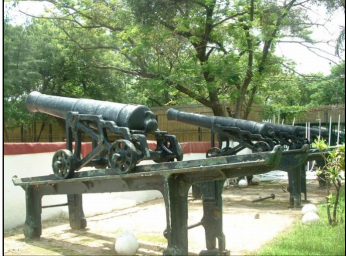
located in Banjul on the south bank of the mouth of the river opposite Fort Bullen.
[/fusion_content_box][/fusion_content_boxes][fusion_text columns=”” column_min_width=”” column_spacing=”” rule_style=”default” rule_size=”” rule_color=”” class=”” id=””]
According to the World Heritage Committee’s citation, “these sites together present a testimony to the main periods and facets of the encounter between Africa and Europe along the River Gambia, a historical continuum stretching from pre-colonial and pre-slavery times to independence. The site is particularly significant for its relation to the beginning of the slave trade and its abolition and also documents early access to the interior of Africa”.
The Stone Circles of the Senegambia, the second Gambian world heritage site was listed in 2006 under criteria I and iii. This is also a serial inscription and consists of four sites, two of which are found in Senegal (Sine Ngayene and Wanar), and the other two in The Gambia (Wassu and Kerbatch). The four large groups of stone circles represent an extraordinary concentration of over 1,000 monuments in a band 100 km wide along some 350 km of the River Gambia. The four groups cover 93 stone circles and numerous tumuli and burial mounds, some of which have been excavated to reveal material that suggest dates between 3rd century BC and 16th century AD. Together the stone circles of laterite pillars and their associated burial mounds present a vast sacred landscape created over more than 1,500 years, and reflect a prosperous, highly organized and lasting society1.
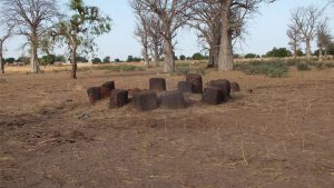
The Stone Circles at Kerbatch
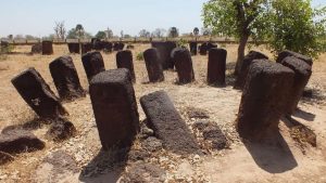
The Stone Circles at Wassu
With these inscriptions the most renowned Gambian cultural heritage sites are now inscribed in the world heritage list. Nevertheless there are other important sites in the country which can be considered for world heritage listing either independently or as extensions to the already inscribed sites.
[/fusion_text][/fusion_builder_column][/fusion_builder_row][/fusion_builder_container]